Dallas I - 345
Proposal to remove one of the most congested highways in Dallas
"The highway system, in its planning and implementation, drove a physical wedge through many parts of America," - former U.S. Transportation Secretary Anthony Foxx.
Precedent Studies
1 - Rochester Highway Removal

Before - The 2.68-mile Inner Loop was built for a more populous city in an era of planning that was dominated by highway engineering and ample federal subsidy for single-use expressways.
The six-lane Inner Loop highway that had for decades divided the eastern part of Rochester, New York, was removed and replaced in 2018 with new complete streets.
The change opened up more than six acres to development — and helped spur more than $250 million in walkable projects.
2 - Milwaukee Park East Freeway Removal
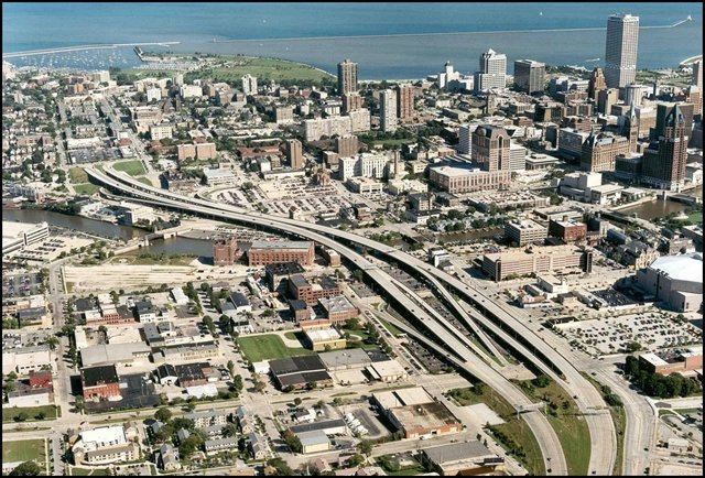
Before - The freeway spur was underutilized and quickly became a blighting influence on the neighborhood. It devalued property and inhibited development on nearby parcels. The debilitating effects of the elevated freeway spur restricted the dominant land use throughout the corridor to surface parking.
In 1999, the State of Wisconsin, Milwaukee County and the City of Milwaukee collectively approved the removal of the spur.
3 - Portland Harbor Drive

Before - One of the first highways in the US to be eliminated to make way for a park was Portland, Oregon’s Harbor Drive built on the shore of the Willamette River. In 1974 the transformation work began that gave rise to Tom McCall Park.
4 - Cheonggyecheon, Seoul – South Korea

Before - The Cheonggyecheon elevated highway in Seoul was built on a canal of the same name. In order to deal with environmental pollution and the noise generated by the more than 160,000 vehicles using the highway daily, Mayor Lee Myung Bak launched a plan to demolish it and build a park instead.
5 - Madrid Río, Madrid

Before - In the year 2000, the Madrid Río project was started, which sought to restore the banks of the Manzares River. A difficult task thanks to the stretches of the M-30 highway that crossed it. As there were several historic structures involved, like the Puente de Segovia, the oldest bridge in the city, the Ermita Virgen del Puerto and Puente del Rey, the project carried out the restoration while maintaining these aspects of the city's history in the middle of the park. In addition, the Puerta del Rey, a building dating back to the reign of José Bonaparte, was able to return to its original location, since it had been displaced during the construction of the motorway.
In the first 20 years of the interstate highway system, construction displaced over a million people across the country. In Miami, Interstate 95 flattened swaths of a Black neighborhood called Overtown, forcing some 10,000 people to leave their homes. Highways radically reshaped cities, destroying dense downtown neighborhoods, dividing many Black communities and increasing car dependence. Amid national conversations on race and justice, advocates have intensified their calls for freeway removal. Such projects have gained momentum in recent years, as the country's highway infrastructure requires ever more expansive, and expensive, repairs.

After - The sunken highway was filled in and the new space created six acres of new development.

After - Certain parts were demolished between 1999 and 2002 for the development of the Park East Corridor project which, when finished, will allow free access from the city center to the river.
The elevated freeway spur was replaced with an at-grade, six-lane boulevard that is fully connected to the existing and newly re-created street grid. New block configurations opened up 24 acres of downtown property for redevelopment.

After - The Hawthorne Bridge, which was originally part of the freeway, became a bridge for cyclists and pedestrians, connecting First Avenue with the park.

After - The selected proposal was designed by Kee Yeon Hwang, who wanted to clean up the canal and return it to its role as a meeting place. In addition, the recovery of this public space has reduced noise levels and temperature in the surrounding area.

After - The park opened in 2011, offering citizens spaces for sports, walks, and opportunities to learn about the city's history. In this instance, the motorway was not completely demolished, but traffic was diverted by underground tunnels.
Dallas Research
Population demographics of Dallas
Income division

I-345 was built in 1973 cutting off two neighborhoods; Deep Ellum and Baylor from downtown Dallas. If it were removed we can rebuild Dallas’ urban core by replacing I-345 with boulevards, and transforming the surrounding 245 acres largely defined by empty parking lots and undeveloped land into mixed use public space with an elevated park, bike paths, a food truck plaza, playgrounds, and community garden space.
Proposal

When I-345 was built it cut off several neighborhoods from the downtown area including Deep Ellum. In our research we noticed that most restaurants were located in the Deep Ellum neighborhood while most of the city’s cultural attractions were located in the downtown area. There is a huge disconnect between downtown and Deep Ellum because of the physical barrier between them.

We propose to completely remove the 1.4 mile long highway and turn one of the lanes into a 60 foot wide elevated park with walking and bike paths. By removing the physical blockade between the Deep Ellum neighborhood and the downtown area it will allow the residents of Deep Ellum to reconnect with downtown and allow people working downtown to enjoy restaurants without having to cross the highway. This will not effect truck routes and will open up more room for bikes and public space. The surrounding parks will be expanded to fill the space that the removed lanes took up and will become basketball courts, a food truck plaza, a dog park, and public space.
By removing the congested stretch of highway the Deep Ellum and Baylor neighborhoods are able to reconnect with the city via the 1.4 mile long stretch of public space. Traffic is rerouted through the reconstructed street grid which brings more business to the restaurants that were once cut off. Dallas’s urban core is reconfigured, and the 245 acres of undefined empty lots and undeveloped land has a purpose and serves the city as public space. The inner city becomes more accessible and breathable by removing one of the most congested highways in the state of Texas. The food truck plaza further helps Deep Ellum restaurants reconnect with downtown by providing close proximity to downtown businesses and residents. This mile long stretch offers the residents of Dallas a place to connect from both sides of the divided network.
